Within Suriname
How an Imaginary Golden Lake Entered Real Maps
Lake Parime became believable when explorers' claims were copied into authoritative maps of the Guianas.
On this page
- What Raleigh and other promoters claimed
- How copied maps turned rumour into geography
- Why surveys finally removed the lake
Page outline Jump by section
Introduction
For more than two centuries, European maps showed a vast inland lake in the Guiana region and a wealthy city called Manoa on its shores. Although the supposed Lake Parime was never found, it became one of the most successful geographical myths in cartographic history. The legend mattered to the wider Guianas, including the colonial territory that later became Suriname, because it transformed rumours of gold and incomplete exploration into what looked like established geographical fact. Once the lake appeared in respected atlases, the story of El Dorado no longer seemed like a traveller’s tale. It appeared to be a place that could be located, measured and reached. The history of Lake Parime shows how repeated copying by trusted authorities can turn uncertainty into apparent knowledge, and how difficult it can be to remove an error once it has entered authoritative maps.[Wikipedia]WikipediaLake ParimeLake Parime
What Raleigh and Other Promoters Claimed
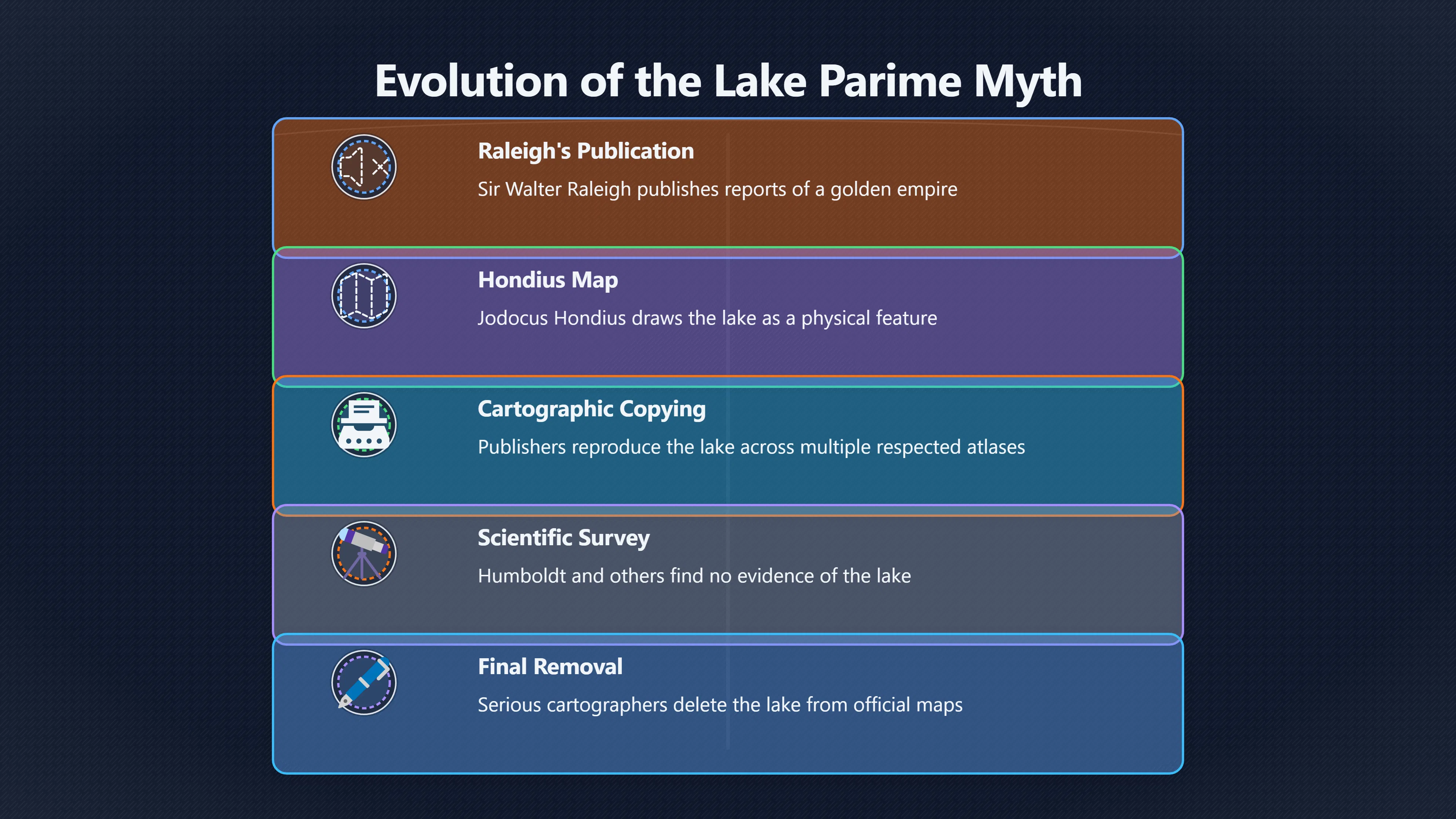
The most influential early promoter of the inland golden kingdom was Sir Walter Raleigh. After his 1595 expedition into the Orinoco region, Raleigh published The Discoverie of the Large, Rich, and Bewtiful Empyre of Guiana in 1596. He described a powerful city called Manoa, associated with the El Dorado tradition, and linked it to a great inland lake. Raleigh never reached the supposed location, but he presented reports from Indigenous informants and second-hand accounts as evidence that a rich empire existed beyond the areas Europeans had explored.[Wikipedia]WikipediaLake ParimeLake Parime
Raleigh had strong incentives to make the story persuasive. He needed royal backing, investors and political support for future expeditions. A golden empire richer than Peru was an attractive prospect for England at a time of rivalry with Spain. His account mixed genuine observation with speculation and hearsay, making it difficult for readers to separate established facts from hopeful inference.[Wikipedia]WikipediaRaleigh's El Dorado expeditionRaleigh's El Dorado expedition
Importantly, Lake Parime was not originally a straightforward invention. Reports of Indigenous goldworking, misunderstandings of seasonal flooding in the Rupununi and neighbouring savannahs, and long-circulating stories about wealthy inland peoples gradually merged into a single geographical narrative. European readers often treated these separate traditions as evidence for one enormous lake and one fabulous city.[DLR ELIB]elib.dlr.deELIBRemote Sensing ArchaeologyDLR ELIBRemote Sensing Archaeology - Searching for Lake Parime…June 2, 2022 — by JM Perez Gomez · 2019 — In his 1625 map of Guiana, mo…
How Copied Maps Turned Rumour into Geography
The crucial step in the myth’s development was its transfer from travel literature into cartography. In 1598 the Dutch cartographer Jodocus Hondius published a map of Guiana showing Lake Parime and the city of Manoa. The lake was drawn as a substantial geographical feature rather than a speculative possibility. Hondius’s map became highly influential and was soon reproduced by other publishers.[Wikipedia]WikipediaLake ParimeLake Parime
Once the image entered widely circulated atlases, it gained a credibility that written reports alone could not provide. Readers naturally assumed that a feature appearing on multiple maps had been independently verified. In reality, many cartographers were copying earlier maps rather than gathering new evidence. The repetition created an illusion of confirmation.[oldworldauctions.com]oldworldauctions.comA Cataloger's Perspective: Mapping South AmericaAfter Sir Walter Raleigh's account of Guiana in 1596, Lake Parime and El Dorado (or Manoa…
Throughout the seventeenth century the lake appeared on maps by leading European mapmakers. Although its shape and exact position often changed, several features remained remarkably consistent:
- A large inland lake somewhere between the Orinoco and Amazon basins.
- The city of Manoa or El Dorado located on or near its shore.
- Vast surrounding territories portrayed as rich in gold and other resources.
- Limited acknowledgement that the information was based on uncertain reports.[Wikipedia]WikipediaLake ParimeLake Parime
The irony was that inconsistencies often strengthened rather than weakened belief. When explorers failed to find the lake, cartographers frequently moved it rather than abandoning it. A lake shifted eastward, southward or deeper into the interior could always remain just beyond the reach of the latest expedition. The myth adapted to new information instead of collapsing under it.[DLR ELIB]elib.dlr.deELIBRemote Sensing ArchaeologyDLR ELIBRemote Sensing Archaeology - Searching for Lake Parime…June 2, 2022 — by JM Perez Gomez · 2019 — In his 1625 map of Guiana, mo…
For colonial audiences interested in the Guianas, including territories associated with present-day Suriname, these maps suggested that the interior still contained extraordinary wealth awaiting discovery. Publishers benefited from dramatic maps, explorers gained potential patrons, and governments could point to the possibility of rich inland territories when justifying imperial ambitions.[oldworldauctions.com]oldworldauctions.comA Cataloger's Perspective: Mapping South AmericaAfter Sir Walter Raleigh's account of Guiana in 1596, Lake Parime and El Dorado (or Manoa…
Why the Maps Looked Convincing
Modern readers often wonder how such a large imaginary lake could survive for so long. Part of the answer lies in the limited geographical knowledge available at the time.
The interior of the Guiana Shield remained poorly mapped for centuries. Coastal settlements existed, but vast areas inland were known mainly through fragmented reports. Seasonal flooding created enormous temporary wetlands, and descriptions of these flooded landscapes could be misunderstood by Europeans unfamiliar with local conditions. Some explorers may have heard accounts of large inundated areas and interpreted them as evidence for a permanent inland sea.[DLR ELIB]elib.dlr.deELIBRemote Sensing ArchaeologyDLR ELIBRemote Sensing Archaeology - Searching for Lake Parime…June 2, 2022 — by JM Perez Gomez · 2019 — In his 1625 map of Guiana, mo…
Cartography itself also encouraged persistence. Early modern mapmakers often worked by combining older maps, travellers’ narratives and scattered observations. Features inherited from respected predecessors were not easily discarded. Removing a famous lake required confidence that generations of earlier authorities had been wrong. Keeping it on the map was often the safer professional choice.[UMM Digital Well]digitalcommons.morris.umn.eduand 18th century represent a period of transition in French cartography. Prior to the turn of the 17th century traditionalism and…Read…
The visual authority of maps amplified this effect. A reader might question a dramatic story in a book, but a lake drawn with shorelines, rivers and place names appeared objective. The map transformed possibility into apparent measurement. Lake Parime became persuasive not because evidence improved, but because the presentation looked increasingly scientific.[oldworldauctions.com]oldworldauctions.comA Cataloger's Perspective: Mapping South AmericaAfter Sir Walter Raleigh's account of Guiana in 1596, Lake Parime and El Dorado (or Manoa…
Why Surveys Finally Removed the Lake
By the eighteenth century, explorers and geographers were becoming more sceptical. Repeated expeditions failed to locate either the great lake or the golden city. Some investigators reported only smaller lakes and seasonally flooded plains where earlier accounts had suggested a vast permanent body of water.[Wikipedia]WikipediaLake ParimeLake Parime
One important change came from cartographers who began marking the feature as doubtful. Guillaume Delisle, among the most respected geographers of his era, questioned the traditional placement of Lake Parime and treated it increasingly as an unverified claim rather than an established fact.[Wikipedia]WikipediaLake ParimeLake Parime
Scientific exploration around the turn of the nineteenth century dealt the most serious blow to the legend. Alexander von Humboldt and other investigators gathered far more reliable geographical information about northern South America and found no evidence for the enormous lake shown in earlier atlases. As surveys improved, the gap between mapped geography and observed geography became impossible to ignore.[Wikipedia]WikipediaLake ParimeLake Parime
The lake did not disappear overnight. Some nineteenth-century writers continued to defend its existence or reinterpret it as a seasonally flooded region rather than a permanent lake. Yet increasingly accurate mapping left little room for the old vision of a gigantic inland sea with a golden capital on its shores. By the early nineteenth century, most serious cartographers had removed Lake Parime from their maps.[Wikipedia]WikipediaLake ParimeLake Parime
What Lake Parime Reveals About Cartographic Error
Lake Parime is best understood not as a simple hoax invented by a single deceiver, but as a powerful example of how errors spread through trusted systems of knowledge. Raleigh’s claims helped popularise the idea, but the legend endured because mapmakers repeatedly copied and refined earlier representations. Each new map appeared to confirm the last.[Wikipedia]WikipediaLake ParimeLake Parime
The case is especially relevant to the history of the Guianas because it demonstrates how colonial-era uncertainty could be transformed into apparent certainty. In a region that included what became Suriname, European audiences often knew little about the interior. Cartography filled those gaps with confidence that exceeded the available evidence.[oldworldauctions.com]oldworldauctions.comA Cataloger's Perspective: Mapping South AmericaAfter Sir Walter Raleigh's account of Guiana in 1596, Lake Parime and El Dorado (or Manoa…
Today Lake Parime survives as a classic example of a cartographic myth: a feature that became believable not because explorers proved it existed, but because authoritative maps made it look real. Its story remains a reminder that maps are powerful tools of knowledge, yet they can also preserve and spread misconceptions when speculation is mistaken for observation.[oldworldauctions.com]oldworldauctions.comLake Parime and the Golden City & Symbolism…By the turn of the 18th century, Lake Parime and El Dorado begin disappearing from maps, w…
Amazon book picks
Further Reading
Books and field guides related to How an Imaginary Golden Lake Entered Real Maps. Use these as the next step if you want deeper reading beyond the article.
A History of the World in Twelve Maps
Explains how myths become embedded in authoritative maps.
The discoverie of the large, rich, and bewtiful empyre of Guiana
Direct source for the Lake Parime and Manoa tradition.
eBay marketplace picks
Marketplace Samples
Live-tested eBay searches with available results related to this page.

Endnotes
1.
Source: Wikipedia
Title: Lake Parime
Link:https://en.wikipedia.org/wiki/Lake_Parime
2.
Source: oldworldauctions.com
Link:https://www.oldworldauctions.com/info/article/2019-10
Source snippet
A Cataloger's Perspective: Mapping South AmericaAfter Sir Walter Raleigh's account of Guiana in 1596, Lake Parime and El Dorado (or Manoa...
3.
Source: Wikipedia
Title: Raleigh’s El Dorado expedition
Link:https://en.wikipedia.org/wiki/Raleigh%27s_El_Dorado_expedition
4.
Source: elib.dlr.de
Title: ELIBRemote Sensing Archaeology
Link:https://elib.dlr.de/133510/1/Remote%20Sensing%20Archaeology%20-%20Searching%20for%20Lake%20Parime%20from%20Space-.pdf
Source snippet
DLR ELIBRemote Sensing Archaeology - Searching for Lake Parime...June 2, 2022 — by JM Perez Gomez · 2019 — In his 1625 map of Guiana, mo...
Published: June 2, 2022
5.
Source: oldworldauctions.com
Link:https://www.oldworldauctions.com/info/article/2014-10
Source snippet
Lake Parime and the Golden City & Symbolism...By the turn of the 18th century, Lake Parime and El Dorado begin disappearing from maps, w...
6.
Source: Wikipedia
Link:https://en.wikipedia.org/wiki/Lake
7.
Source: digitalcommons.morris.umn.edu
Link:https://digitalcommons.morris.umn.edu/cgi/viewcontent.cgi?article=2163&context=jmas
Source snippet
and 18th century represent a period of transition in French cartography. Prior to the turn of the 17th century traditionalism and...Read...
8.
Source: store.steampowered.com
Link:https://store.steampowered.com/app/1118240/Lake/
9.
Source: mapmyths.com
Title: el dorado
Link:https://mapmyths.com/blog/el-dorado/
Additional References
10.
Source: raremaps.com
Link:https://raremaps.com/gallery/detail/63739/guiana-sive-amazonum-regio
Source snippet
[Lake Parime and El Dorado] Guiana sive Amazonum RegioOne of the best early decorative maps of the Amazon region, published by Jan Jansso...
11.
Source: helmink.com
Link:https://www.helmink.com/antique-map/18872/jodocus-hondius-map-of-el-dorado-1598-nieuwe-caerte-van-het-wonderbaer-ende-goudrijcke-landt-guiana-gelegen-onder-de-linie-aequinoctiael
Source snippet
Antique map of El Dorado by Jodocus Hondius for sale.This Hondius map is based on the discoveries of Sir Walter Raleigh's 1595 first ques...
12.
Source: youtube.com
Title: El Dorado: The Golden City That Never Was | Mythical Dark History for Sleep
Link:https://www.youtube.com/watch?v=nYcKmnMw8Ok
Source snippet
Walter Raleigh's Bloody Quest To Find The City Of Gold | Great Adventurers...
13.
Source: youtube.com
Title: Walter Raleigh’s Bloody Quest To Find The City Of Gold | Great Adventurers
Link:https://www.youtube.com/watch?v=h0RJbK_oyJk
Source snippet
50 Geography Facts That Are Fake (But You Believed Them)...
14.
Source: youtube.com
Title: The Hunt for El Dorado: Unveiling the Lost City
Link:https://www.youtube.com/watch?v=qdfPua-uTYE
Source snippet
El Dorado: The Golden City That Never Was | Mythical Dark History for Sleep...
15.
Source: youtube.com
Title: 50 Geography Facts That Are Fake (But You Believed Them)
Link:https://www.youtube.com/watch?v=nao4bzb2RiY
Source snippet
Maps Lied for Centuries (Phantom Islands Explained)...
16.
Source: facebook.com
Link:https://www.facebook.com/groups/640476949304851/posts/7293365680682578/
17.
Source: facebook.com
Link:https://www.facebook.com/ancientoriginsweb/posts/explore-the-captivating-tale-of-cibola-the-mythical-seven-cities-of-gold-and-the/879381377563727/
18.
Source: facebook.com
Link:https://www.facebook.com/groups/1653910321314304/posts/5892925860746041/
19.
Source: stolenhistory.org
Title: manoa el dorado lake parime the lost city of gold and the headless people.63
Link:https://www.stolenhistory.org/articles/manoa-el-dorado-lake-parime-the-lost-city-of-gold-and-the-headless-people.63/
Topic Tree